Welcome!
Hello and welcome to my weather blog! I will be posting each day about the weather conditions, yesterday's forecast, and predict the weather in the coming days. Each post will start with a quick glance of the current conditions and then I'll elaborate on the rest of the previously listed content.
Current Conditions:
Temperature: 28 degrees, feels like 17 degrees
Humidity: 58%
Winds: west at 13 mph
Pressure: 1008.1 mb
Visibility: 10 miles
I woke up this morning to snow, which I was not expecting! It was an accumulation of 2-3 inches, so nothing major.
 |
| Figure 1. View of the bottom of the hill on the UW-Eau Claire campus. The snowfall was minor and the roads were already plowed by 8:00 AM. |
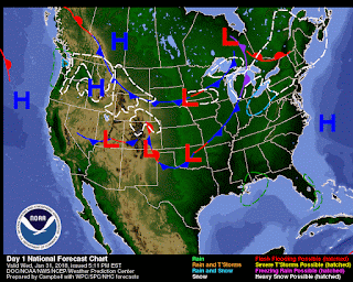
The sky was completely overcast and the temperature was a toasty 29 degrees with winds WSW at 10 mph. The snow most likely came from a low pressure front that moved in from the north.
 |
| Figure 2. A map courtesy of NOAA showing low and high pressure fronts. The low pressure currently in Minnesota and western Wisconsin has created a pocket of snowfall (denoted in the map) and the high pressure front following it will most likely be the culprit of the cold temperatures in the coming days. |
By noon the temperature had risen to 29 degrees and the sky was completely clear and sunny. At around 5:00 pm the temperature was 28 degrees and the winds had picked up to 13 mph out of the west. Caution is advised tonight with wind chills from -15 to -25 and a chance of snow. Based on the high pressure front following the low pressure area, tomorrow should be mostly sunny and colder than today. Long term there could be some snow this weekend Friday to Saturday and wind chills -20 to -25 Saturday and Sunday.

