Tuesday, May 8, 2018

May 8, 2018

Rain!

Current Conditions

Temperature: 59 °F
Dew Point: 54 °F
Winds: S 10 mph
Pressure: 1013.5 mb
Visibility: 10 miles

Today started off warm and mild and transitioned to the storms that we're seeing now. The surface map in figure 1 shows the low pressure system that moved into the area carrying rain and cooler temperatures with it.
Figure 1. Surface map of the United States.
There is a series of low pressure systems moving eastward and bringing some precipitation with them. Unfortunately this means that the coming days will be much cooler...
The storm that is currently over Eau Claire, WI can be seen in the water vapor satellite image in figure 2 as well.
Figure 2. Water vapor satellite image of the United States.
The cloud cover over Wisconsin in general is quite apparent in the image. Hopefully this low pressure system will clear up by next week, but the start of a stationary front just to the north of us and the southerly wind direction has me wary.

Previous Prediction

Yesterday's prediction was spot on! We had a low pressure system move into the area and it brought with it overcast skies.

Prediction

The low pressure system doesn't seem to be going anywhere so I would guess that skies will continue to be overcast tomorrow with much lower temperatures.

This post marks the end of my semester-long weather blog for this class. I look back at my first posts and realize how much my knowledge of weather expanded over the course of the semester. It was a fun ride, but now its time to move onto bigger and better things, like graduating...

Monday, May 7, 2018

May 7, 2018

Hot n' Toasty

Current Conditions

Temperature: 76 °F
Dew Point: 42 °F'
Winds: WSW 6 mph
Pressure: 1014.9 mb
Visibility: 10 miles

Today was a predictable day given the high pressure dome in the area. The skies were clear in the morning with partly cloudy skies later this evening. The whole country experienced similar weather conditions, meaning no severe or interesting weather (figure 1).
Figure 1. Surface map of the United States.
The surface map shows the high pressure dome sitting over the Midwest and the northeast creating clear skies and beautiful summer-like conditions. There is a small amount of rain to the west of Wisconsin but that shouldn't impact the area until tomorrow morning.

Temperatures were also quite high today. Figure 2 shows the high temperatures for the country.

Figure 2. High temperatures for the United States.
In figure 2 one can see the high temperatures at the most extreme from western Texas up through the Plains. Although those high temperatures feel nice, we should see a drop in temperature in Wisconsin starting tomorrow as the rain hits.

Previous Prediction

Yesterday's prediction was spot on; we had higher temperatures and clear skies because of the high pressure dome.

Prediction

For tomorrow I would expect overcast skies as a low pressure system moves into the area. There will most likely be some rain showers tomrrow evening into tomorrow night as the low pressure system moves closer to western Wisconsin (figure 3).
Figure 3. Prediction map for May 8, 2018.

Sunday, May 6, 2018

May 6, 2018

Perfect Day for Running

Current Conditions

Temperature: 72 °F
Dew Point: 34 °F
Winds: N 7 mph
Pressure: 1019.0 mb
Visibility: 10 miles

Today was absolutely gorgeous. The morning was a bit cooler and temperatures soon rose into the low 70s with clear skies turning to partly overcast later this afternoon. The Eau Claire marathon was today and runners could not have asked for a better day. The nice weather can be attributed to the high pressure dome that is currently sitting over Wisconsin (figure 1).
Figure 1. Surface map of the United States.
The high pressure dome is not just creating clear skies for Wisconsin but also for much of the Midwest. There are some rain showers in the northwest and northeast but these are small-scale storms that should not cause any damage. The water vapor satellite image for today in figure 2 shows the cold fronts in the surface map as dark lines (indicating no moisture).
Figure 2. Water vapor satellite of the United States.
As I mentioned earlier it did get cloudier today. Mid-morning there were a few cirrus clouds which morphed into a stratus layer of cirrus that then transitioned into cirrocumulus clouds (figure 3).
Figure 3. Cirrocuulus clouds over UW-Eau Claire.
I was not able to capture it but the cirrus clouds created a halo around the sun that was pretty neat to see!

Previous Prediction

The temperature did cool off from yesterday, but it was by no means any less nice of a day. There was also a thunderstorm last night that I didn't predict happening.

Prediction

For tomorrow we should continue to see fair skies due to the northerly wind and cirrus clouds in the sky. Also expect the temperature to rise as the high pressure dome moves farther south.

Saturday, May 5, 2018

May 5, 2018

Scorcher

Current Conditions

Temperature: 78 °F
Dew Point: 36 °F
Winds: W 8 mph
Pressure: 1012.2 mb
Visibility: 10 miles

What a beautiful day, just the kind of weather that makes you want to sit inside a testing center for 5 hours am I right? Just kidding, that's a big no, but it couldn't be helped. What most people did was go outside and enjoy the 80 DEGREE WEATHER. You heard right. What a great day. Skies were clear early this morning and the temperature only continued to climb throughout the day. The high pressure dome is still in the area which is creating those clear skies (figure 1).
Figure 1. Surface map of the United States.
There is a small bit of cloud cover now but it shouldn't be making any precipitation. With how warm it was today, I would guess that the cloud cover we're experiencing is due to convection and not a separate moisture source. Speaking of the warm temperatures, we can thank the jet stream for pulling those up from the Gulf (figure 2).
Figure 2. Jet stream map over the United States.
If you look back to my past couple of posts, you might notice that the jet stream is slowly shifting eastwards, which may mean cooler temperatures in the future. We'll have to wait and see what actually happens though.

Previous Prediction

Yesterday's prediction was correct with a high temperature of 80 °F and clear skies. I for one am happy to see this prediction come true.

Prediction

Tomorrow skies will again be clear with no fronts in sight, but the temperature might cool off a bit with a new high pressure dome moving into the area (figure 3).
Figure 3. Prediction map for April 6, 2018.


Friday, May 4, 2018

May 4, 2018

May the 4th be with You

Current Conditions

Temperature: 72 °F
Dew Point: 31 °F
Winds: NW 10 mph
Pressure: 1013.2 mb
Visibility: 10 miles

Today was a gorgeous day all around. The temperature started in the low 60s and steadily climbed into the 70s with mostly clear skies (figure 1).
Figure 1. Weather overview for Eau Claire, WI on May 4, 2018.
The dew point depression is more than 40 degrees so there's no chance of thunderstorms today either. Winds have gotten a bit gusty at times but with the warm weather those winds feel quite nice. Taking a look at the surface map, Eau Claire isn't experiencing any interesting weather at the moment (figure 2).
Figure 2. Surface map of the United States. 
The high pressure dome that's sitting on the entire western and central portion of the states is keeping those skies clear and sunny. A cold front with associating low pressure fronts is creating some heavy thunderstorms in the northeast but nothing severe. In the southeastern United States the Bermuda High is over Florida which is creating clear skies down there as well.

Previous Prediction

Yesterday's prediction was correct; we got warm weather in the 70s and mostly clear skies.

Prediction

For tomorrow expect even warmer temperatures that might even peak into the 80s with clear skies becoming more cloudy as the day progresses. I wouldn't expect any rain however.

And finally, may the 4th be with you all...

Thursday, May 3, 2018

May 3, 2018

Hot and Muggy

Current Conditions

Temperature: 62 °F
Dew Point: 58 °F
Winds: SE 9 mph
Pressure: 1009.5 mb
Visibility: 10 miles

Today turned out to be hot and and steamy! The temperature quickly rose into the mid-70s by early afternoon and the wind speeds were relatively low. The skies became overcast later in the evening and by 6:30 PM there was a slight drizzle. This was short-lived however and it isn't predicted to rain until later tonight. Figure 1 shows an overview of the weather conditions today. 
Figure 1. Weather overview for May 3, 2018.
In the northeastern United States residents have been experiencing record highs this past week. That will be coming to a close tomorrow when the storm system that caused the severe weather in the Plains will be barreling through the area. It is expected to created high winds, thunderstorms, and even tornadoes (figure 2). To read more, go here.
Figure 2. Wind and thunderstorm predictions for the northeastern United States.
The storm system heading to the northeast is following the current jet stream path that can be seen in figure 3. 
Figure 3. Jet stream on May 3, 2018.

Previous Prediction

The skies definitely cleared up as I had predicted, but the temperature was the same if not higher than yesterday's high temperature. We also had rain last night which I did not predict. 

Prediction

Tomorrow should bring clear skies and more warm weather with temperatures in the mid to upper-70s. 

Wednesday, May 2, 2018

May 2, 2018

Humidity Strikes

Current Conditions

Temperature: 67 °F
Dew Point: 44 °F
Winds: W 8 mph
Pressure: 1010.8 mb
Visibility: 10 miles

Today started off quite foggy and humid. There were low stratus clouds in the sky and a drizzle falling around 7:00 AM. Down by the Chippewa River there was steam fog along the banks as well. However the temperature was still mild sitting in the upper 50s. As the day progressed the skies cleared up and we saw sun by the early afternoon. The surface map in figure 1 shows the cold front now to the east of Eau Claire that had passed over late last night and early this morning.
Figure 1. Surface map of the United States.
One can see that now there is a high pressure dome sitting over Wisconsin which should bring clearer skies in the coming days. While Wisconsin is sitting in the clear, Oklahoma and Kansas are another story. The Rockies have set up a nice barrier for warm, moist air that is coming in from the Gulf and being pulled up by the jet stream (figure 2).
Figure 2. Jet stream moving up through the United States pulling moist air in from the Gulf of Mexico.
This air is creating severe weather in the plains where tornadoes are supposed to hit tonight. The weather vapor satellite image in figure 3 shows the moisture that is  fueling the severe storms in the area.
Figure 3. Water vapor satellite of the United States.
This seems extreme but May is the beginning of tornado season for the area so we should expect severe weather like this to continue for the summer.

Previous Prediction

The front passed slower than I expected so there was still some cloud cover and rain this morning. However the temperature did drop today, although I was expecting lower temperatures than what we received.

Prediction

For tomorrow I would expect cooler temperatures due to the high pressure air mass that will be in the area. Skies should clear up because of the passing front and the now westerly wind direction.

Additional Information

Here's an interesting weather story from Accuweather that describes what conditions will be like across the United States in summer 2018. The predictions are made by a special long-term forecaster, which I had not heard of before. Check it out!

Tuesday, May 1, 2018

May 1, 2018

Another Gorgeous Day in Wisconsin

Current Conditions

Temperature: 70 °F
Dew Point: 55 °F
Winds: SSW 9 mph
Pressure: 1007.4 mb
Visibility: 10 miles

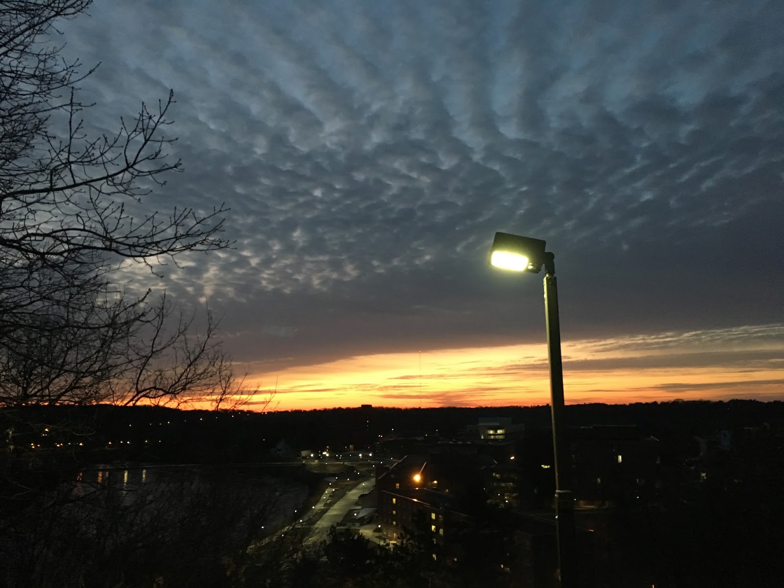
Today was another gorgeous day that started off with a fantastic sunrise (figure 1).
Figure 1. Sunrise on May 1, 2018.
What the picture doesn't show is the approaching altostratus clouds and the cumulus mediocris that foretold of the incoming cold front from the west. This was an exciting sight to see because this meant incoming storms, and we haven't had a good storm yet this year. As the day went on, the temperature increased as well as the cloud cover. The surface map in figure 2 shows the cold front and associated low pressure systems.
Figure 2. Surface map of the United States.
Although the cooler weather came with the front, the storms passed just to the south of us. The sky is currently overcast with cooler weather setting in from the high earlier today of 76 °F (figure 3).
Figure 3. Temperature map of the United States.
Although Wisconsin isn't seeing any severe weather, the southern United States, particularly from
Oklahoma to Iowa is a different story. The incoming warm and moist air of the maritime tropical air mass is coming up through Texas and heading northwards. The jetstream is the force pulling it north. The Rockies are acting as a barrier between the moist warm air and the cooler dry air to the west. This is creating the perfect conditions for a dryline which is then producing the severe weather. May is also the month with the most tornadoes in the United States, and it looks like Oklahoma could be seeing one in the next couple days. The water vapor satellite image in figure 4 shows the incoming moisture that is feeding this weather system.
Figure 4. Water vapor satellite image of the United States.

Hopefully Wisconsin will get to see some severe weather another time...

Previous Prediction

My previous prediction was incorrect, there was not any precipitation (although I wish there had been some). However it is worth noting that all the indicators were there such as the SSW wind and the cloud progression from cirrus to stratus.

Prediction

By tomorrow the front should have passed so the area will be experiencing cooler temperatures with the incoming continental polar high pressure air mass in addition to some cloud cover from the back end of the front.

Monday, April 30, 2018

April 30, 2018

A Toasty Day

Current Conditions

Temperature: 80 °F
Dew Point: 44 °F
Winds: SSW 14 mph
Pressure: 1006.4 mb
Visibility: 10 miles

Well what a nice day today! Temperatures peaked at 83 °F and winds stayed relatively low making the conditions ideal for any outdoor activities today! However it wasn't just Wisconsin that experienced a warm day. Across the US temperatures were higher than they have been the past couple of weeks (figure 1).
Figure 1. High temperatures for the United States on April 30, 2018.

In particular, you can see the warmest temperatures round out on the bottom of Arizona and New Mexico and move northwards through the Great Plains. This happens to be following the current jet stream shown in figure 2.
Figure 2. Jet stream over the United States.
Although the temperatures are nice, in the southeastern United States this warm weather from the jet stream spells bad weather for them. Luckily the severe weather won't be reaching Wisconsin. Speaking of adverse weather, the surface map for today is showing some precipitation heading our way now (figure 3).
Figure 3. Surface map of the United States.
This line of storms is headed our way tomorrow and creates the possibility for some rain and thunderstorms. I for one am looking forward to a nice storm since we haven't had one yet this spring.

Previous Prediction

Yesterday's prediction had the right idea, some warmer weather and an approaching warm front. By this evening the cloud cover had begun to thicken, signaling the approaching precipitation which is also hinted at by the wind direction.

Prediction

Speaking of wind direction and clouds, the cirrus clouds this morning that have morphed into patchy altostratus clouds and the SSW wind direction hint at the warm front approaching from the west that is sure to bring at least some precipitation tomorrow. Break out those umbrellas and rain boots!

Sunday, April 29, 2018

April 29, 2018

Lazy Sunday Weather

Current Conditions

Temperature: 65 °F
Dew Point: 21 °F
Winds: S 12 mph
Pressure: 1020.7 mb
Visibility: 10 miles

Today was a relaxing Sunday with mild temperatures all day. Currently its 65 °F which is the high for today. Figure 1 shows the clear skies for the Midwest due to the high pressure dome in the area.
Figure 1. Surface map of the United States.
The high pressure dome almost looks like a bulldozer clearing away the clouds and low pressure systems to the east and west. Speaking of which, the northwest United States is experiencing some precipitation from the low pressure systems being fed by that maritime polar air current feeding moisture into the area. Other than this, there is no appreciable weather happening in the country.

Figure 2 is a wind map of the United States and shows just how powerful the high pressure dome in the area is.
Figure 2. Wind map of the United States.
If you look at the entire Midwest you can see the clockwise wind pattern from the high pressure system. Pretty impressive I'd say! In the west you can also see the divide in the winds caused by the warm front coming our way.

Previous Prediction

Yesterday's was another easy prediction; warmer temperatures today with no cloud cover.

Prediction

For tomorrow expect some cloud cover but continued warm temperatures as a warm front approaches from the west. We shouldn't be seeing any rain though (figure 3)!

Figure 3. Prediction map for the United States on April 30, 2018.

Saturday, April 28, 2018

April 28, 2018

Clear and a Little Cool

Current Conditions

Temperature: 55 °F
Dew Point: 14 °F
Winds: NE 13 mph
Pressure: 10233.7 mb
Visibility: 10 miles

Today was calm and clear. There were no clouds this morning and the sky stayed clear the rest of the day. The temperature rose steadily after 9:00 AM this morning and peaked at the current temperature of 55 °F (figure 1).
Figure 1. Weather overview for the United States on April 28, 2018.
 Winds have been calm except for a couple of hours of gusts that came out of the north. The barometric pressure has also risen today which can be attributed to the high pressure dome shown in figure 2.
Figure 2. Surface map of the United States.

The high pressure dome has left the Midwest with some cooler weather from the continental polar air mass but clear skies. The northeastern United States is experiencing some rain from a low pressure system as is the western coast, but nothing that is causing any damage.

Previous Prediction

Yesterday's prediction was correct: clear skies and cooler temperatures.

Prediction

As the high pressure dome continues to move south, expect warmer temperatures tomorrow with continued clear skies.

Friday, April 27, 2018

April 27, 2018

The Clouds are Coming

Current Conditions

Temperature: 52 °F
Dew Point: 36 °F
Winds: ENE 18 mph
Pressure: 1008.8 mb
Visibility: 10 miles

Today was relatively calm. The cloud have been changing throughout the day but no precipitation yet. This morning a layer of cumulostratus clouds were lining the sunrise (figure 1).
Figure 1. Sunrise with cumulostratus clouds above. 
By the afternoon the sky had a mix of cirrus, cumulofractostratus, and cumulus humilis clouds. These clouds are from the incoming cold and partial warm  front in figure 2.
Figure 2. Surface map of the United States.
The surface map in figure 2 shows the cloud cover over much of the state currently with some possible precipitation. The eastern coast is also experiencing some precipitation from a series of low pressure systems.
In addition, the increased cloud cover in our area is dropping the temperature a bit earlier than it has in previous days (figure 3).
Figure 3. Weather overview for Eau Claire, WI on April 27, 2018.
Around 2:00 PM today the temperature began to fall. The barometric pressure has risen slight, but not by much. In the next hour Eau Claire could be seeing some precipitation which is possible given the cloud cover and the weather conditions in figure 3.

Previous Prediction

Yesterday I was correct about the cooler temperatures and increased cloud cover but there is a chance for precipitation.

Prediction

By tomorrow the front should have passed clearing up the skies. However with the incoming cooler air expect lower temperatures in the 50s.

Thursday, April 26, 2018

April 26, 2018

Warming Up Again!

Current Conditions

Temperature: 67 °F
Dew Point: 35 °F
Winds: W 20 mph
Pressure: 1008.8 mb
Visibility: 10 miles

Today was a beautiful day. The morning was a bit chilly with a temperature of 32 °F and low winds. By the afternoon the temperature had risen to the low 60s and the winds had also picked up (figure 1).
Figure 1. Weather overview for Eau Claire on April 26, 2018.
The barometric pressure has also dropped throughout the day. Taking a look at the sky, we have a mix of different clouds (figure 2).
Figure 2. Sky in Eau Claire on April 26, 2018.
We have a few cumulus humilis in the background with some cirrocumulus and altocumulus that are not pictured. This morning there was a solid cirrostratus cloud cover that then converted to what we have now. This sequence is predictive of the cold front that we have coming into the area which is shown in figure 3.
Figure 3. Surface map of the United States.
While there is some cloud cover now, once the front passes things should clear up.

Previous Prediction

Yesterday's prediction regarding the cloud cover was correct, there was definitely an increase. However today's temperature was warmer than predicted, which is definitely not a bad thing!

Prediction

Tomorrow things should cool off with the approaching cold front. We should also be seeing some increased cloud cover as the front moves closer to the area. We will not be getting any precipitation though.

Wednesday, April 25, 2018

April 25, 2018

Cooling Down a Bit

Current Conditions

Temperature: 54 °F
Dew Point: 28 °F
Winds: NNW 8 mph
Pressure: 1020.7 mb
Visibility: 10 miles 

Today's skies cleared up from last night with not a cloud in the sky by 9:00 AM. The surface map in figure 1 supports this observation.
Figure 1. Surface Map of the United States.
Right now Wisconsin is between two cold fronts, which means clear weather for us but some overcast skies could become prevalent in the next day or two. Throughout the day the temperature steady rose from 32 °F this morning to a high of 61 °F. Although the temperature was fairly warm, the winds kept it feeling cool with winds up to 10 mph (figure 2). 
Figure 2. Weather overview for Eau Claire, WI on April 25, 2018.
In other areas of the US things are relatively quiet. The western US has a seen a spike in temperatures this week reminiscent of summer, but that should subside by next week. 

Previous Prediction

Yesterday's prediction was correct: skies were clear and there was definitely abundant sunshine. It was a little disappointing how much cooler it was today though. 

Prediction

For tomorrow temperatures will be similar to today but with an increase in cloud cover due to the approaching cold front to the north (figure 3).
Figure 3. Predictive map of the United States for April 26, 2018.

Tuesday, April 24, 2018

April 24, 2018

Yet Another Beautiful Day

Current Conditions

Temperature: 48 °F
Dew Point: 36 °F
Winds: NNE 4 mph
Pressure: 1022.3 mb
Visibility: 10 miles

Today started off with clear skies and a temperature of 35 °F with no winds. As the day progressed some cirrostratus clouds moved in followed by altocumulus clouds. By early evening stratus clouds were covering portions of the skies. This progression along with the wind direction indicate a low pressure system moving in to the area. Indeed, the surface map in figure 1 shows just that.
Figure 1. Surface map of the United States.
Just to the south of Wisconsin is a low pressure system. Because winds rotate counter-clockwise around a low pressure system, the winds to the north of it come from the E/NE direction, which is exactly what Eau Claire is experiencing.
The increase in cloud cover can also be seen in the water vapor satellite image in figure 2.

Figure 2. Water vapor satellite of the United States.
In the northeast there is some light precipitation, but otherwise the country is currently looking quite in terms of weather.  However, next week we could be seeing some interesting weather. A fast-moving airstream over the United States will experience a trough over the Arizona/New Mexico also called an Omega trough. After the air comes out of the trough, it produces 'divergence aloft' which means the air is diverging from the narrow trough it came out from. This means that air can rise in the area directly below which creates storms. The increase in moisture and temperature will add to this scenario and create a severe weather risk in the southern United States (figure 3).
Figure 3. Omega trough projected for the United States next week.

Previous Prediction

Yesterday's prediction was correct; the temperature was lower and there was increased cloud cover from yesterday. There also was no precipitation.

Prediction

Surprisingly, tomorrow we should see some more clear skies. The predictive map shows the low pressure system moving out of the area and taking the cloud cover with it (figure 4). Go enjoy the sunshine while you can!
Figure 4. Predictive weather map of the United States for April 25, 2018.

Monday, April 23, 2018

April 23, 2018

Is it Summer Yet?

Current Conditions

Temperature: 67 °F
Dew Point: 28 °F
Winds: 0 mph
Pressure: 1020.0 mb
Visibility: 10 miles

Today was another beautiful yet uneventful day. This morning's sky consisted of some cirrostratus and cirrocumulus clouds that quickly faded by early morning (figure 1).
Figure 1. Sunrise on the UW-Eau Claire campus.
Temperatures rose from the upper 30s to the upper 60s by mid-afternoon. Winds were minimal, occasionally gusting up to 5 mph. Figure 2 shows the barometric pressure drop, which although small is hinting at the low pressure system moving in from the west.
Figure 2. Weather overview for Eau Claire, WI.
Figure 2 also shows the large dew point depression which means there's no rain in the forecast for tonight!
In the surface map in figure 3, one can see the low pressure system to the west that will be moving into the area tomorrow.
Figure 3. Surface map of the United States.
This low pressure system is causing relatively low precipitation compared to the low pressure system in the southeastern United States which is currently creating flooding conditions in the Carolinas. Otherwise, things seem fairly quite across the country and certainly much more subdued compared to last weekend when the blizzard hit! On a good note, Oklahoma is set to have the latest start to tornado season yet, so maybe there is some good coming out of this weird spring weather...

Previous Prediction

Yesterday's prediction was correct; the weather was warmer, even getting up to 70! If I didn't have so much homework I would have spent some of the day outside of the geography lab...

Prediction

Tomorrow will be overcast and about 10 degrees colder than today due to some cloud coverage from the low pressure system to the west. This shouldn't produce any precipitation however (figure 4).
Figure 4. Forecast surface map for April 24, 2018.


Sunday, April 22, 2018

April 22, 2018

A Beautiful Day

Current Conditions


Temperature: 63 °F
Dew Point: 30 °F
Winds: S 7 mph
Pressure: 1025.7 mb
Visibility: 10 miles

What a fantastic day! The temperature was beautiful, peaking in the low 60s today with clear skies (figure 1).
Figure 1. Sky on the UW-Eau Claire campus.
Today proved to be even nicer than yesterday, which was hard to beat. As figure 2 shows, the low barely dipped below 30, and the high today went up to 63 degrees. Winds were minimal with mainly southerly winds. There were a few cirrostratus clouds this morning but the sky cleared up so the southerly wind won't be bringing any weather our way for a while.
Figure 2. Overview of the weather for Eau Claire, WI on April 22, 2018.
Last night was the Lyrid meteor shower, and it did not disappoint! Skies were perfectly clear and the meteors were fairly consistent. Getting out in the early hours of the morning was well worth it!

Looking at the surface map in figure 3, the southeastern United States has a low pressure system creating some rain events for the area, but luckily its staying away from the Midwest (for now).
Figure 3. Surface map of the United States.

Previous Prediction

Yesterday's prediction was on point; low 60s although the sky did clear up for most of the day.

Prediction

For tomorrow, expect more clear skies and warm temperatures due to the southerly wind bringing up that warm air! The temperature should be in the mid-60s with low wind speeds, a perfect day to spend outside (figure 4).
Figure 4. Prediction map for the United States on April 23, 2018.