Snow Time
Current Conditions
Temperature: 30 °F
Dew Point: 28 °F
Winds: NNE 7 mph
Pressure: 1010.2 mb
Visibility: 0 miles
Today started off a bit warmer than yesterday at least with a temperature of 28 °F and winds NNE at 7 mph. The low pressure system that moved in yesterday continued to dump snow on Eau Claire overnight and the trend definitely continued today. In figure 1 a surface map shows the large snow system currently over most of Wisconsin.
 |
| Figure 1. Surface map of the United States on April 3, 2018. |
The low pressure system is also shown in figure 2. The water vapor satellite image shows a large amount of moisture in the exact location of the low pressure system currently sitting over Iowa.
 |
| Figure 2. Water vapor satellite image of the United States. |
The temperature and pressure changes over time as the low pressure system moved eastward is visualized in figure 3.
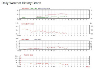 |
| Figure 3. Weather graphs of Eau Claire, WI. |
Since last night the barometric pressure has consistently dropped which mirrors the passage of the low pressure system over the area. The temperature and dew point have both risen and have stayed a consistent distance apart.
Previous Prediction
Yesterday's prediction was correct. All day it has been snowing.
Prediction
Tomorrow's going to be cooler since the low pressure system is moving out and a high pressure system is moving in. Overcast skies will dominate with some patches of sun here and there. Let's hope this is the last big snow, or snow in general that we get this spring.


No comments:
Post a Comment