Goodbye Snow, Hello...Cold?
Current Conditions
Temperature: 27 °F
Dew Point: 10 °F
Winds: W 11 mph
Pressure: 1021.3 mb
Visibility: 10 miles
Today started out a bit chillier than I was expecting with a temperature of 13 °F and a dew point of 2 °F. Skies were sunny with winds NW at 8 mph. This cold snap is the result of a high pressure system bringing in cold arctic air from Canada. After such a big snowfall, the temperature and moisture content have taken quite the dive, shown in figure 1.
 |
| Figure 1. Weather graphs for Eau Claire, WI on April 4, 2018. |
Temperatures did reach 30 degrees today, but the winds kept things chilly. Notice the dew point temperature plummeted today which creates a large dew point depression and thus a low moisture content in the air. I'm not sure if I'm happy to have the snow gone or mad because the cold is back.
Currently skies are clear and will continue to be with the high pressure system currently in the area (figure 2).
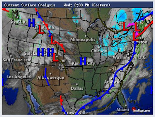 |
| Figure 2. Surface map of the United States on April 4, 2018. |
The surface map shows clear skies for Wisconsin, but the low pressure system that hid the Midwest yesterday is barreling towards the east coast and will dump more snow on an area that has seen 4 nor'easters in March. The specifics of this are in a weather story on accuweather and can be accessed
here.
Previous Prediction
My prediction of cooler temperatures was correct but skies were clear all day.
Prediction
Tomorrow is going to be very similar to today: clear skies and cooler temperatures, although it might be a bit warmer tomorrow. Let's hope this cold streak ends soon. I'm ready for some shorts weather!


No comments:
Post a Comment