Wednesday, February 28, 2018

February 28, 2018

Another Warm Day

Current Conditions

Temperature: 40 °F
Dew Point: 33 °F
Winds: ENE 4 mph
Pressure: 1013.2 mb
Visibility: 9 miles

Today wasn't quite as warm as yesterday so I didn't wear shorts, but it was still warm.  This morning the temperature was 29 °F with sunny skies and winds NNE at 4 mph. By the afternoon the temperature had risen to 41 °F with winds ENE at 4mph. The winds are still from the same direction and the temperature hasn't changed much since then. 

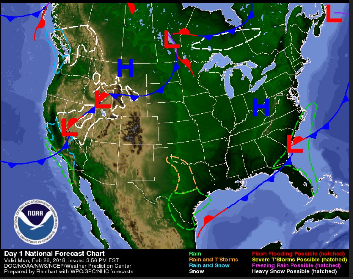
Right now the satellite and radar maps are looking a little crazy. Figure 1 is the surface map from NOAA and the least busy map out of all the ones I found.
Figure 1. NOAA surface map of the United States.
 In the west we have high pressure air masses and in the southeast United States is a series of low pressure air masses that are wreaking havoc in the south. In the map one can see rain, thunderstorms, flooding, and a host of mixtures of these precipitation types. The rain from the low pressure systems is causing flooding in the Ohio River valley and other areas in the Arkansas region. The next map in figure 2 is also a surface map but has radar added in.
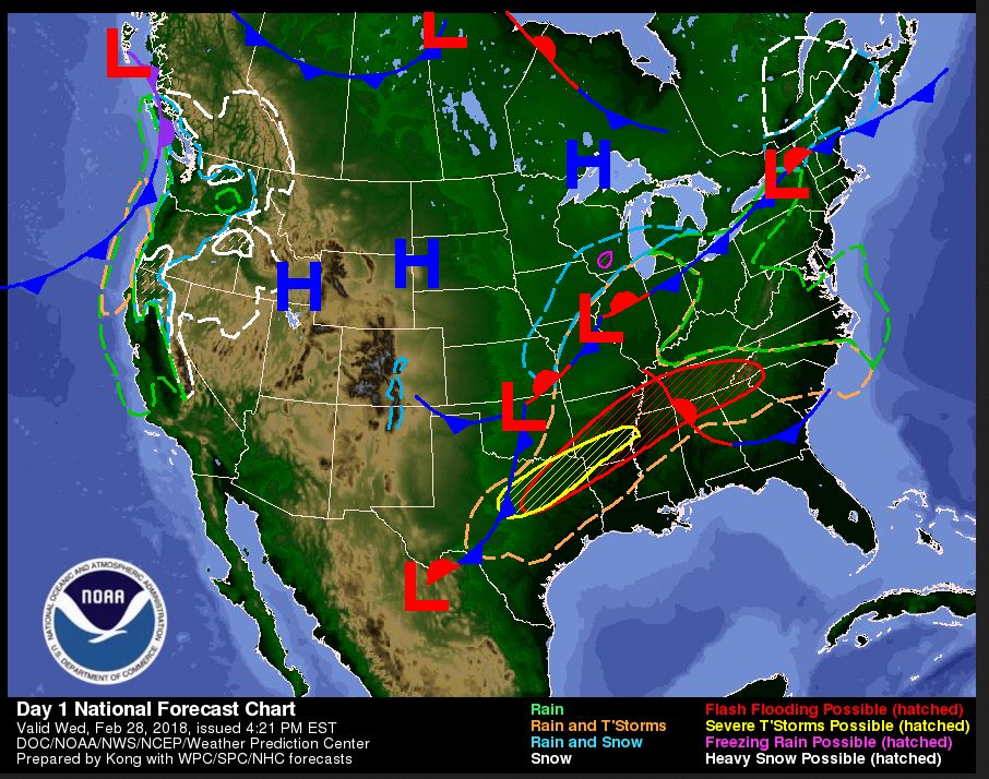
Figure 2. Intellicast mixed surface map of the United States.
 Here is where things get crazy. This map shows more of the low pressure systems along the high pressure front. The warm air is coming from the Gulf coast and bringing warm, moist air that's meeting the cold air from the north and creating heavy rain and thunderstorms. In the Wisconsin area the front is creating snow that will possibly fall tomorrow. In figure 3 is an image of winds in the upper atmosphere that shows where the moist air is coming from. 
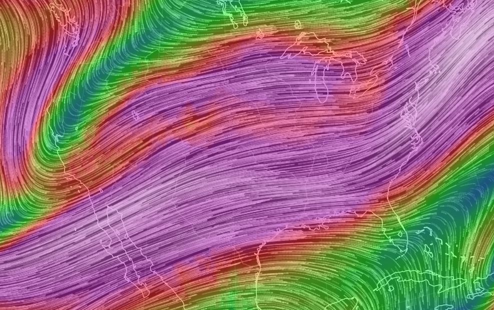
Figure 3. Wind map of the upper atmosphere.
 The winds are coming off the Pacific and moving over the Gulf and the United States. What's bizarre to me is what looks like the jet stream in the top left corner being cut off by this sudden strong wind current. I'm not quite sure what the explanation is here.
Next in figure 4 is a satellite image of the water vapor which follows the path of the strong air current shown in figure 3. 
Figure 4. Water vapor satellite image.
 Figure 4 shows the water vapor coming from the Pacific and Gulf coast that's causing the heavy rain and thunderstorms in the south. 

 Previous Prediction

My prediction from yesterday was correct; cooler temperatures from the high pressure systems.

 Prediction

For tomorrow, I predict cooler temperatures with cloud cover and possible snow. This is from the low pressure systems to the south of Wisconsin right now. Of course this could change between now and tomorrow depending on how far north the precipitation from the low pressure systems reaches. 

Tuesday, February 27, 2018

February 27, 2018

Shorts Weather!

Current Conditions

Temperature: 35 °F
Dew Point: 26 °F
Winds: 0 mph
Pressure: 1010.8 mb
Visibility: 10 miles

Today the temperature reached a toasty 50 °F, so the shorts definitely came out! This morning the temperature was 23 °F with no winds and clear skies. The afternoon was much the same except the temperature continued to climb up to 50 °F. Other than the warm temperatures, there was not a lot going on in the Eau Claire area today. 

The warm weather can be attributed to the southerly wind direction at the surface and the direction of the jet stream explained in figures 1 and 2 respectively. 
Figure 1. Map of the surface winds in the United States. The winds in the Eau Claire, WI area are originating from the south and bringing warm air with them.
Figure 2. The jet stream is coming off the Pacific Ocean and heading up through Mexico bringing warm, moist air into the Midwest this week.
In the current surface map a couple of things can be noted (figure 3). Over the Wisconsin region is a low pressure system which indicates the warmer air. There is a stationary front in our area as well which means temperatures aren't changing. In the south near Louisiana there is severe flooding due to continued thunderstorms. This area and up into Kentucky experienced severe thunderstorms and tornadoes last week and the continued rain is making matters worse. Flooding is also causing issues in the Ohio River Valley near Columbus. 
Figure 3. Mixed surface map of the United States.
While the rest of the United States is experiencing warm temperatures, the west coast is experiencing uncharacteristically cold temperatures. In figure 2 one can see the dip in the jet stream denoted by blue. This is bringing in cold air from the continental polar air mass and keeping temperatures low. 

My prediction from yesterday was correct, temperatures were definitely warmer. 

For tomorrow, I predict slightly cooler temperatures because of the high pressure air mass to the north that will continue to descend into the area. And let's be honest, these warm of temperatures never last long during winter in Wisconsin.

Monday, February 26, 2018

February 26, 2018

Sunny and Warm

Current Conditions

Temperature: 38 °F
Dew Point: 23 °F
Winds: S 8 mph
Pressure: 1018.3 mb
Visibility: 10 miles

Today was a gorgeous day in Eau Claire with sunny skies and very warm temperatures! This morning it started out a bit cool with a temperature of 8°F and no winds. By the afternoon the temperature had risen to 34 °F with winds SSW at 10 mph. The light breeze was a perfect match to the warm temperatures that peaked at 44 °F. The rest of the country doesn't seem to be experiencing any extreme weather, although the southeast is recovering from severe storms and tornadoes after the last line of low pressure systems made its way across the United States. Much of the warm weather can be attributed to the jet stream which is currently coming off the Pacific Ocean and heading northeast (figure 1). 
Figure 1. Wind map of the jet stream over the United States.
 My prediction from yesterday was mostly right except there were no clouds. The warm temperatures and winds were present though. 

For tomorrow, I predict more warmer weather due to the southerly winds and lack of any other fronts near the area as shown in figure 2. 
Figure 2. Surface map of the United States.
 

Sunday, February 25, 2018

February 25, 2018

Bright and Snowy

Current Conditions

Temperature: 27 °F
Dew Point: 19 °F
Winds: WSW 14 mph
Pressure: 1010.2 mb
Visibility: 10 miles

Today was sunny throughout the day with a few clouds. The snow hit Eau Claire late last night and into the early morning hours. This morning it was 22 °F with winds WSW at 14 mph and occasional gusts. The afternoon was much the same and so was this evening. The temperature did rise to 30 °F this afternoon, but  otherwise other conditions stayed the same. 

Elsewhere in the country, four people are confirmed dead after severe storms hit the southern United States. There was extensive flood damage and tornadoes. Click here to read the full article from accuweather.com. 

My prediction from yesterday was correct to a T. Of course, the forecast map did help quite a bit. 

For tomorrow, I predict there will be some lingering clouds but warmer temperatures. This is because the prevailing wind direction is south, so the winds will likely bring warmer air to the north than normal. With the low pressure system still in the region, winds may still be present. The higher winds can be identified on the map by the closer isobars, which indicates a higher pressure gradient (figure 1). 
Figure 1. Mixed surface map of the United States. Closer isobars in the Wisconsin-Minnesota region indicate higher winds and the low pressure system that is just to the north is bringing warmer air as it travels north.


Saturday, February 24, 2018

February 24, 2018

The Snow is Coming

Current Conditions

Temperature: 32 °F
Dew Point: 25 °F
Winds: E 13 mph
Pressure: 1010.5 mb
Visibility: 3 miles

Before 11:00 AM today it was overcast and foggy with 4 mile visibility and a temperature of 12 °F. By the afternoon the sun started peeking out and the temperature rose to 31 °F with winds ENE at 10 mph. Around 4:00 PM there were some light snowflakes coming down but  these dissipated by 5:00 PM. As stated above the winds are now out of the east at 13 mph and the temperature is relatively the same as it was at noon. 

Currently we have a hot (or should I say cold?) mess of weather going on (figure 1). 
Figure 1. Radar image of the United States.
 If you look to Wisconsin, you'll see some rain and snow events brewing. Eau Claire is of course right on the border of both of these, so who knows what the weather will actually do. The snow and rain are products of a low pressure front that is moving towards the area (figure 2). 
Figure 2. Surface map of the United States
 This map outlines the snow and rain areas and shows the low pressure front that's just below Wisconsin and Minnesota.  The lower pressure value for today is an indicator of this incoming system. This will likely move in this evening and dump some white stuff whiles it cruises through. 

Yesterday I predicted snow in the afternoon and slightly warmer temperatures. Temperatures did warm up a tad, but the snow is not here yet. This snow will probably hit tonight.

For tonight and tomorrow I predict snow until the early morning hours and then partly sunny skies tomorrow with higher winds. This forecast is based off the forecast map in figure 3. 
Figure 3. Forecast map for Sunday February 24th, 2018.
 

Friday, February 23, 2018

February 23, 2018

Snow!

Current Conditions

Temperature: 28 °F
Dew Point: 22 °F
Winds: WSW 9 mph
Pressure: 1024.0 mb
Visibility: 6 miles

This morning there was at least 3 inches of wet, heavy snow on the ground! It was a beautiful site to see. The temperature this morning was 28 °F with a dew point of 27 °F. This equates to a 2 degree dew point depression. This small of a dew point depression indicates the air has a high moisture content for its temperature. The sky was overcast with fog and a light drizzle until around 10:00 AM. At noon the temperature was almost the same at 29 °F and winds were W at 13 mph with overcast skies. There were no other major events during the day and even now the temperature hasn't changed much. The winds however are now turning south which should be bringing some interesting weather up to Wisconsin and Minnesota (figure 1). 
Figure 1. Surface map of the United States.
 As mentioned yesterday, a bomb cyclone is heading to Wisconsin and Minnesota that is originating in the Missouri region. With winds coming out of the south, this low pressure system will be sent straight to the area tomorrow. Figure 2 shows the weather advisory map from the national weather service. Notice that Eau Claire, WI is sitting right on the boundary of the winter weather advisory. This means that we may or may not get hit with major snow fall.
Figure 2. Weather advisory map of the national weather service.
 The precipitation can also be viewed on the water vapor satellite in figure 3. 
Figure 3. Water vapor satellite image.
 From this image it is easy to see where the moisture is and its path heading northeast towards Wisconsin. 

My prediction from yesterday hit the nail on the head. Snow fell overnight and today was overcast with temperatures similar to yesterday. 

Tomorrow I predict that there will be snow in the afternoon and temperatures a tad warmer than today. This is because with snow events the temperature generally increases.

Thursday, February 22, 2018

February 22, 2018

Warm Once Again

Current Conditions

Temperature: 30 °F
Dew Point: 12 °F
Winds: E 12 mph
Pressure: 1033.2 mb
Visibility: 10 miles

The weather has taken a turn for the warmer side today which means overcast skies from dawn until dusk. This morning the temperature was 6 °F and the dew point was 3 °F with winds NE at 4 mph. The wind direction is a first since I started my weather blog and is visualized in figure 1. 
Figure 1. Wind map from earth.nullschool.net. Notice the northeastern winds traveling over Wisconsin and the line crossing the southeastern United States. This line is the mixed front that moved over Eau Claire a few days ago.
  The rest of the day was overcast as well. By noon the temperature was up to 24 °F and winds were now ENE at 7 mph. As noted in the current conditions, the temperature did continue to climb up to 30
°F which is much appreciated this time of year. In figure 2 the water vapor satellite shows a small band of water vapor makings its way through the Midwest which is probably the source for the weather we're about to get.
Figure 2. Water vapor satellite image of the United States. Notice the stream of water vapor moving from Mexico to Wisconsin.
The water vapor trail shown in figure 2 is following the current path of the jet stream in figure 3. 
Figure 3. Jet stream map.
Finally, all of these images help explain the crazy weather about to hit the area that is partially described by the surface map in figure 4. 
 
Figure 4. Surface Map of the United States.

Before I proceed, I want to note that my previous forecast was correct: there was increased cloud cover and slightly warmer temperatures.

Returning to the surface map, right over the Eau Claire area is the boundary between heavy snow and freezing rain. These events are poised to strike either early tonight or into the early morning hours tomorrow. Although this might seem unfortunate, its nothing compare to what's coming on Saturday and maybe Sunday. A large snow event, possibly even snow thunder, will arrive from the south. This is created by what's called a bomb cyclone. Bomb cyclones are created rapidly and result in extreme weather events like snow thunder. This will not show up on the surface or radars until late Friday or early Saturday. So tomorrow there should be some snow on the ground from tonight and most of the day will be overcast with temperatures comparable to today. Of course, this is just the calm before the storm...

Wednesday, February 21, 2018

February 21, 2018

Burrrrr!

Current Conditions

Temperature: 17 °F feels like 11 °F 
Dew Point: 4 °F
Winds: W 8mph
Pressure: 1038.9 mb
Visibility: 10 miles

Today was even cooler than yesterday with a high of only 19 °F and wind chills. This morning the temperature was only 1 °F and felt like -1. The dew point was -2 °F which creates a small dew point depression but the air is so dry that precipitation will not occur. The sky was sunny with a few cirrus clouds mixed in and winds SSW at 5 mph. At 12:00 PM winds shifted to the west at 8 mph and the temperature rose to 11 °F. Currently winds are still out of the west and the temperature is just slightly higher at 17 °F. The drop in temperature is due to the high pressure air mass moving into Wisconsin that originated in the continental polar air mass (cold, dry air). This is shown in figure 1. 
Figure 1. Surface map of the United States.
Figure 2 is a temperature map of the U.S. that illustrates the movement of temperature zones with fronts. One can see the cold temperatures following the path of the low pressure systems moving across the country. 
Figure 2. Temperature map of the United States.
My previous forecast was correct; cooler temperatures followed the high pressure air mass and there were sunny skies with no precipitation.

For tomorrow I predict some increased cloud cover and slightly warmer temperatures but not too much different than today. This is based off the forecast surface map in figure 3.
Figure 3. Forecast surface map of the United States.


Tuesday, February 20, 2018

February 20, 2018

Freezing Rain

Current Conditions

Temperature: 17 degrees, feels like 8 degrees
Dew Point: 11 degrees
Winds: W 8 mph
Pressure: 1023.0 mb
Visibility: 10 mph

This morning the temperature was 21 degrees with N 4 mph winds. The dew point was 19 degrees indicating a high moisture content in the air. Early this morning there was a remnant of the freezing rains the Eau Claire area received yesterday but the rain mostly stopped by 8:00 AM. Over the course of the day the sky stayed over cast and the high temperature was 22 degrees. Light fog was present in the early afternoon. Currently the temperature is dropping and winds have shifted to the west.

The current surface map shows a great example of a mid-latitude cyclone. Mid-latitude cyclones are characterized by a series of low pressure systems moving together. This has created a trough spanning the entire United States! In figure 1 a surface map shows the line of precipitation that is following the low pressure trough.
Figure 1. Surface map of the United States with precipitation events.
This precipitation is a result of the cooler air from the continental polar air mass colliding with the warm air following the jet stream to the south (figure 2).
Figure 2. Jet stream coming off the southern Pacific Ocean and carrying moist air into the Midwest.
The air carried by the jet stream has a large amount of water vapor indicated in figure 3.
Figure 3. Water vapor following the pattern of the jet stream. The water vapor is responsible for the precipitation along the low pressure systems.


Yesterday I predicted that the temperature would be about the same and it was. The wintry mix was still present but not as much as I was expecting.

Tomorrow I predict that temperatures will be cooler due to the high pressure air mass moving into the area shown in figure 1. The low pressure systems are moving south which means no precipitation for the time being.

Monday, February 19, 2018

February 19, 2018

A Wintry Mix

Current Conditions

Temperature: 23 degrees, feels like 11 degrees
Dew Point: 22 degrees
Winds: NE 9 mph
Pressure: 1010.8 mb
Visibility: 1 mile

This morning started out at 29 degrees and the temperature only dropped after that. Winds were out of the NNE at 10 mph and the sky was overcast. These conditions continued until 11:00 AM when a snow/sleet mix began to fall. At noon the temperature dropped to 25 degrees and winds picked up to 13 mph. The snow and sleet transitioned to rain late this afternoon and slowed to a drizzle by 5:00 PM. Despite the temperature dropping, it was still mild outside compared to a couple weeks ago (figure 1).
Figure 1. High temperatures in the United States. Wisconsin is mostly green, which indicates a temperature in the 30s.
My prediction from yesterday was correct, snow was a part of the weather today. Temperatures were also cooler.

For tomorrow, I predict that the temperature will be around the same and we will continue to see this wintry mix. These conclusions are based off of the surface map for tomorrow shown in figure 2. The key here is the stationary front sitting just below Wisconsin. Neither the warm or cold air mass is moving, and at the front the two air masses cause precipitation. The same conditions will prevail because the front will not move from where it was today.
Figure 2. Surface map of the United States. The orange and blue colors near Eau Claire indicate either ice or snow.

Sunday, February 18, 2018

February 18, 2018

Another Gorgeous Day

Current Conditions

Temperature: 40 degrees, feels like 28 degrees
Dew Point: 25 degrees
Winds: S 17 mph
Pressure: 1006.4 mb
Visibility: 10 miles

This morning started out with 100% cloud cover and a temperature of 19 degrees. The rest of the morning was much of the same with winds out of the SE at 7 mph. At noon the temperature was 34 degrees and winds were SSE at 19 mph. Then early afternoon the clouds began to break and it remained partly sunny the rest of the afternoon. The temperature right now will be the high today, and not too shabby of one at that.

My prediction from yesterday was incorrect. In fact, we actually have a low pressure system sitting on our doorstep instead of a high pressure system. The temperature was also much warmer than yesterday not cooler.

Speaking of the low pressure system, there is one approaching western Minnesota and eastern Wisconsin causing a winter weather advisory for the area through Tuesday (figure 1).
Figure 1. Low pressure system heading towards eastern Wisconsin and likely bringing snow and sleet.
This can also be inferred from the pressure decrease from yesterday. Today the pressure is 1006.4 mb and yesterday it was 1017.6 mb.

These factors indicate that there will be snow tomorrow, although I couldn't say how much. The temperatures will continue to be high, probably in the low 20s due to the southerly winds that bring warm air to Wisconsin in the winter. I do think that the temperature won't climb to what it was today because of the cloud cover and precipitation expected.

Saturday, February 17, 2018

February 17, 2018

Snow!

Current Conditions

Temperature: 23 degrees, feels like 15 degrees
Dew Point: 12 degrees
Winds: W 8 mph
Pressure: 1017.6 mb
Visibility: 10 miles

Today started out cloudy in the morning and transitioned to snow mid-morning to early afternoon. Around 1/1.5 inches accumulated which didn't amount to much. Figure 1 below shows the snow beginning to fall as I was out on my morning run.
Figure 1. Snow falling around 8:15 AM on walking bridge over the Chippewa River.
By late afternoon the skies had cleared and the sun was shining. Temperatures peaked a 29 degrees with winds SSW at 8 mph. the southerly winds explains the warmer temperatures experienced today. Now the wind has shifted and is coming out of the west.

My prediction from yesterday was correct! The southerly winds brought warmer weather and there was indeed snow today.

For tomorrow, I predict that temperatures will be cooler because a high pressure air mass is sitting over Wisconsin and winds are now coming out of the west (figure 2).
Figure 2. Surface map of the United States. Note the high pressure air mass over the upper Midwest.


Friday, February 16, 2018

February 16, 2018

Cooling Off

Current Conditions

Temperature: 10 degrees, feels like 2 degrees
Dew Point: -2 degrees
Winds: S 7 mph
Pressure: 1022.3 mb
Visibility: 10 miles

Today was uneventful like the rest of the week. Temperatures were definitely cooler this morning at 1 degree feeling like -9. Winds were out of the west at 8 mph and the sky was clear.  By noon the temperature peaked at 5 degrees and winds were the same as this morning. The high today was 15 degrees, quite a bit cooler than the high of 33 yesterday. The pressure has also gone up, an indicator that a high pressure air mass is sitting over Wisconsin again.

The rest of the United States is also uneventful as high pressure fronts are dominating from coast to coast. Figure 1 shows the locations of the high pressure fronts.
Figure 1. Current surface map for the United States.
My prediction from yesterday was correct: high pressure fronts moved in from Canada and the temperature dropped.

For tomorrow, I predict that temperatures will warm up again because the winds are coming out of the south, and southerly winds bring warmer weather to Wisconsin in the winter. There could also be a chance for precipitation because there is a stream of water vapor going from west to east from the Pacific Ocean (figure 2).
Figure 2. Line of water vapor going from the Pacific Ocean and moving eastward. The water vapor stream shows up dark on the map.

Thursday, February 15, 2018

February 15, 2018

The Warmth Continues

Current Conditions

Temperature: 33 degrees, feels like 25 degrees
Dew Point: 23 degrees
Winds: NNW 9 mph
Pressure: 1011.5 mb
Visibility: 10 miles

Today was also warm compared to last week, and it was much needed! This morning at 8:00 AM the temperature was 28 degrees with no wind. The clouds that were present around seven this morning had dissipated by 8:30 AM and the rest of the day was clear skies and sunny. At noon the temperature jumped to 41 degrees with winds NNW at 10 mph. Towards the late afternoon there were some cirrus clouds accounting for roughly 40% cloud cover. These clouds persisted through the evening.

Not much happened in Wisconsin, but other parts of the country are experiencing some precipitation events, especially the southeastern United States (figure 1).
Figure 1. Precipitation map of the United States on February 15, 2018 courtesy of Intellicast.
I referenced the rain in the south yesterday as possible events that will lead to flooding next week. This prediction seems to be accurate so far, but this weather could change quickly too.

My prediction was wrong from yesterday, but I am completely okay with warmer than predicted temperatures.

For tomorrow, I predict that there will be a drop in temperatures as the low pressure areas continue to dissipate with the high pressure front moving in from Canada. This can be seen in figure 2.
Figure 2. Surface map of the United States. Note the high pressure system in the northern part of the country.
Also interesting to note is the precipitation showing up in figure 1 over the western part of the country. This can be explained in figure 2 by the stationary front that is present. This means that neither the low or high pressure front is moving the other, so they are sitting at a stalemate and causing precipitation from the moist air hitting the cooler dry air.

Wednesday, February 14, 2018

February 14, 2018

Am I Dreaming?

Current Conditions

Temperature: 42 degrees, feels like 36 degrees
Dew Point: 30 degrees
Winds: SSW 10 mph
Pressure: 1004.1 mb
Visibility: 10 miles

I asked if I was dreaming today because the high temperature was 48 degrees. Just last week we were in the negatives with wind chill! Wisconsin can be an unpredictable place sometimes. The day started out sunny and foggy with a temperature of 27 degrees and winds out of the south at 7 mph. Towards the afternoon the fog cleared and the temperature rose to the upper 30s with winds slightly increasing to S 10 mph. By the evening the temperature had cooled, but it was still 42 degrees outside. Figure 1 shows the temperatures of the lower 48 states. You can see the polar air pushed back into Canada.
Figure 1. Temperatures on February 14, 2018 in the contiguous United States.
The low pressure fronts have been welcome in the northern part of the country but are causing problems in the southeastern part of the states. Flash flood warnings are expected from Arkansas to West Virginia and Pennsylvania by the middle of next week. Rain events as a result of the low pressure fronts are adding precipitation that the hardened ground cannot hold and could potentially cause flash flooding if the snow melts in the Ozark Mountain region. Figure 2 shows where the rain events will likely occur.
Figure 2. Rain events predicted for next week.
As far as my prediction from yesterday, I was correct that temperatures would increase, but I low-balled the estimate because we actually reached the upper forties!

For tomorrow, temperatures will continue to be warm, but will drop into the 30s due to the low pressure air mass moving farther away from Wisconsin. Figure 3 shows the moving low pressure fronts and the high pressure system from the north bearing down on Wisconsin.
Figure 3. Map of high and low pressure systems in the United States.